Monday, October 14, 2013

The Skagit Valley's Big Rock With Spencer Jack's Grandma Cindy & The Nookachamp Star Child Falling From The Sky

Big Rock On Fire July 18, 2013
Yesterday my great nephew, Spencer Jack's grandma, Cindy, emailed me a couple pictures from the summit of the Skagit Valley's monolith known as Big Rock.

Earlier in the week, after Cindy mentioned hiking up Big Rock, I had asked if a parking lot has been added near the trail head.

The answer was no parking lot. Still  roadside parking only.

Big Rock is located on the east side of the town of Mount Vernon, about 2 miles from where I lived when I resided in Washington. Big Rock was one of my frequent hiking destinations.

The last time I saw Big Rock was in April of 2006. At that point in time I was surprised to see how close to Big Rock a housing development had been built. One of Cindy's pictures surprised me due to showing that now a housing development is encroaching upon Big Rock from the west.


The view above is looking west from atop Big Rock at the housing development which has sprung up in the last 7 years.

Below is a view from the Big Rock summit looking northeast, at Clear Lake and Cascade Mountain foothills.


Big Rock has a long history in the Skagit Valley, looming large as a sacred spot of the Nookachamp tribe, which called Big Rock "Yudwasta" which means "Heart".

As in Heart of the Nookachamp nation.

In Nookachamp legend Big Rock came to be when the Star Child escaped from a bad marriage to a man who lived in the sky. Star Child returned to earth using a rope she made from cedar saplings. When she got grounded, Star Child's sister, who stayed in the sky, cut the rope so the husband in the sky could not figure out how Star Child escaped.

After the rope was cut it coiled as it fell, forming Big Rock. When the light is right and you look at Big Rock from certain angles you can see how it could come to be that legend has it that the rock formation was made from a coiled rope.

This past summer, on July 18, 2013, fire broke out on the north face of Big Rock, which you will see in the below video...

Friday, August 30, 2013

More Mount Baker Hiking With Cindy, Michele, Ginny & Jeremy

Last Sunday my great nephew Spencer Jack's grandma, she being my favorite ex-sister-in-law, Cindy, emailed me photos of her hiking trek to the Park Butte Lookout near the Mount Baker volcano.

I then blogged about Cindy and her co-hiker, Michele, hiking to the Park Butte Lookout, in a blogging titled Hiking To The Park Butte Lookout With Cindy & Michele.

In that blog post I mentioned several things that I remembered about hiking to Park Butte. Things like the treacherous crossing of what I believe is called Sulfur Creek, with that creek being the melted water coming from the Easton Glacier on the slopes of Mount Baker. And how treacherous I remembered the hike up Park Butte to be.

That is the Park Butte Lookout you see in the above photo. It does not looks as treacherous as my memory remembers it.

Today Cindy emailed me a few more photos from her Park Butte Lookout hike, which illustrate some of what I mentioned in the previous blogging.

I also referenced, in that blogging, Pacific Northwest mountain hiking legend,  Dr. Fred T. Darvill. I'd infosearched Fred T. Darvill and found a memoriam. Dr. Darvill's wife, Ginny is mentioned in that memoriam.


After reading my reference to Dr. Darvill, Cindy sent the above photo with text saying that upon arriving at the Park Butte Lookout Cindy and Michele found someone painting the lookout. That someone turned out to be Dr. Darvill's wife, Ginny, she being the young lady between Cindy and Michele in the photo.

I do not know if by "painting" Cindy means Ginny Darvill was painting the lookout with a fresh coat of paint. Or if she was painting a water color picture of the lookout.

Below is a photo taken from the Park Butte Lookout, looking at the Railroad Grade, that being the name of the trail which runs atop the glacial moraine formed by the Easton Glacier. I am almost 100% certain I have this glacier named correctly. There are several on Mount Baker, Coleman Glacier and Deming Glacier come to mind.


That big slice of ice in the middle of the photo is the glacier. To the right, obscured by clouds, is the top of Mount Baker. That edge that follows the west side of the glacier is the Railroad Grade. Eventually you can go no further without proper ice/snow trekking gear. The last time I hiked the Railroad Grade was with my nephew, Joey. We hiked up to the far upper left of what you see in the photo. At that point you can clearly see the steam venting from Mount Baker's crater.  And smell the sulfur.

In today's email Cindy informed me that the bridge I was familiar with that crossed the glacier melt creek has been long gone, but was replaced a couple weeks ago by the temporary bridge you see below.


Crossing the creek did not look too treacherous for Cindy's most recent crossing, but she says 2 years ago, when she returned from hiking up the Railroad Grade, the return trip across the raging creek was scary.

I remember a couple times crossing that creek, late in the afternoon, where it took a long time because you had to be so careful not to get washed away by the rampaging water. The most recent time was a piece of cake because a well built suspension bridge took you over the creek, well above the water. That is the bridge that Cindy says has been long gone.

Now that I am thinking about that long gone bridge across Sulfur Creek I remember the last time I crossed that bridge. It was with a hiking group of 6 or 7, including my youngest nephew, Jeremy, about 7 at the time, 27 now.

When Jeremy saw the bridge that he was expected to cross he was not happy. It took a lot of coaxing to get him to cross. I remember Jeremy insisting both bridge ends be guarded.

Because Jeremy had watched in horror as several of the group crossed the bridge, having fun making it bounce and sway.

It took Jeremy about 10 minutes to slowly make his way across.

That hike was on a foggy, drizzly August day. By the time we got out of the woods, to the point you usually see Mount Baker, it was totally fogged in. We bailed.

When we got back to the point where the suspension bridge had to be crossed again Jeremy had developed a totally different attitude.

Jeremy's totally adjusted suspension bridge crossing attitude resulted in one of my all time favorite photos....


Wednesday, August 28, 2013

Captain Spencer Jack Piloting A Washington State Ferry In Anacortes

In the picture you are looking at my great nephew, Captain Spencer Jack piloting a Washington State Ferry at the terminal in Anacortes.

When Spencer Jack's dad, my equally great nephew, Jason, was a few years older than Spencer Jack he built the entire Washington State Ferry Fleet in scale model form.

Spencer Jack's dad's Washington State Ferry Fleet went up in smoke, under mysterious circumstances, at some point during the 1990's.

The Washington State Ferry Fleet is the biggest fleet of ferries in the United States. And the third biggest fleet in the world.

Based on the number of vehicles carried annually, at around 11 million, the Washington State Ferry system is the world's largest.

Washington State began ferry operations in 1951. Prior to that the ferry system, known as the "Mosquito Fleet" was a private business operation, with multiple operators, which by 1935 had been reduced to one company operating a fleet, that being the Puget Sound Navigation Company, nicknamed the Black Ball Line.

By the end of the 1940s the Black Ball Line was having labor relations woes with the ferry worker's union, which was demanding wage increases. The Black Ball Line wanted to raise its fares. But the state said no to fare increases. The Black Ball Line then shut down, with the State of Washington taking over ferry operations after paying Black Ball $5 million for all but 5 of its ferry boats.

When the State of Washington took over running the ferry system, in 1951, conventional wisdom of the day thought the state would only run the ferry system until bridges across Puget Sound were built. However, for the most part, no bridges were built, which has the Washington State Department of Transportation still in the ferry business over a half century later.

Cross sound bridges to take the place of ferry boats? Those would be some mighty big bridges. A bridge from Keystone on Whidbey Island to Port Townsend on the Olympic Peninsula? A bridge from downtown Seattle to Bainbridge Island? Bridges from Anacortes to the San Juan Islands?

Cross-sound bridges? Washington would not be Washington without its ferry fleet.

Sunday, August 25, 2013

Hiking To The Park Butte Lookout With Cindy & Michele

Looking West at the Sisters Mountain Range in the Background
In the photo you are looking at my great nephew Spencer Jack's grandma, my favorite ex-sister-in-law, Cindy, with her hiking partner, Michele, at the Park Butte Lookout, near Mount Baker in the Mount Baker - Snoqualmie National Forest.

Last week it was Maxine making me homesick for hiking the Cascade Mountain trails, with Maxine's tales of hiking to Hidden Lake and Park Butte.

I have only hiked to Park Butte one time. I remember it as a difficult hike.

The last time I hiked from Schrieber's Meadow to the Park Butte Lookout trail  zone was with Cindy's youngest, Spencer Jack's uncle, my favorite nephew, Joey. On that hike Joey and I did not hike up to the Park Butte Lookout. We hiked up what is called the Railroad Grade, that being the trail atop the glacier moraine carved out by the Easton Glacier.

Speaking of the Easton Glacier. During warm summer days that glacier melts copious amounts of water. Early in the day this is no big deal. But, by late afternoon the glacial melt becomes a torrent that can be a bit treacherous to cross. Bridges get built and then washed away. I don't know what the current bridge status is regarding the streams one crosses between Schrieber's Meadow and when you begin the climb up the Mount Baker foothill.

Go here to see photos of one of the aforementioned bridges and the hike with Joey up Mount Baker.


In the above photo from Cindy we are looking east towards Baker Lake. Cindy says you can see Baker Lake in the middle of the picture.

The hike to the Park Butte Lookout is 4 miles, making this an 8 mile round trip. The altitude gain, counting ups and downs, is 2,200 feet. The trailhead is 3,350 feet above sea level.

In his book, Hiking the North Cascades, Fred T. Darvill, Jr. says of the Park Butte hike, "The view from Park Butte is one of the best in the North Cascades; this may be one of the most beautiful places in the world. Dominating the scene is the ice-clad cone of Mt. Baker with its satellite peaks, the Black Buttes..."

Fred T. Darvill is sort of a Pacific Northwest mountain legend. In addition to being an ardent hiker and author, he was a doctor. I Googled "Fred T. Darvill" to find a memoriam webpage dedicated to his memory. The first entry in that memoriam is below...

Dr. Fred Darvill MD passed away on December 29. He practiced medicine for 50 years in the Skagit Valley. When his heart wasn't active helping his patients it was climbing peaks in the Cascades. He wrote several books including Stehekin: The Enchanted Valley and Hiking the North Cascades. For twenty years he and his wife Ginny devoted time, energy, and resources toward their adoption of the Hidden Lakes Lookout. Several years ago I found Fred's name written on a summit register. He had placed the register in 1967 at the unnamed highpoint between Desolation and Hozomeen peaks. Our visit was the sixth party to enter the register in nearly 40 years. As he had left his card I called his home and spoke with Ginny. She said she would mention my visit to him and it would probably help him reflect on more pleasant times. His struggle in the closing years was with Alzheimer's. Those who would like to provide a tribute to his service can donate to the Alzheimer's Association or Doctors Without Borders at the request of his wife Ginny.

Tuesday, August 13, 2013

Mudsldes Stop Me From Driving North Cross Cascades Highway 20 To Winthrop This Weekend

I did not know til Maxine told me via email that thunderstorms over the weekend dropped a lot of water on the North Cascades, which caused 8 mudslides between mileposts 150  and 155 on Highway 20, near Rainy Pass.

Highway 20 is now closed at the winter gate at milepost 147, east of Diablo. Coming from the east the highway is closed at milepost 157, east of Rainy Pass.

The biggest of the Highway 20 mudslides is a quarter mile long and 25 feet deep.

Did any vehicles passing over the pass get trapped in the Highway 20 mud mess?

The same storm also caused a major washout on the Cascade River Road at milepost 18. Cascade River Road is how you get to the trail head for the Cascade Pass Trail, which is one of the most popular hiking destinations in the Cascade Mountains. The Cascade Pass Trail is the route one hikes from the west side of the mountains to hike to the Stehekin Valley.

The aforementioned Maxine makes a yearly trek to Stehekin via this route.

The washout on the Cascade River Road stranded 65 hikers and 30 vehicles at the Cascade Pass trail head parking lot. The stranded hikers had to spend the night. By Monday a temporary fix to the washout let the stranded evacuate.

That Washington Trails Association has an excellent website with photos and details about the closed roads.

The Seattle Times has an excellent first person account from one of the stranded Cascade Pass hikers.

Wednesday, August 7, 2013

Walking Across Upper Baker Dam With Spencer Jack

In the picture you are looking at my great nephew, Spencer Jack, taking a picture of the Mount Baker volcano.

This past weekend Spencer Jack took his dad and favorite girl friend, Brittney, to the Mount Baker-Snoqualmie National Forest to drive and walk across the Upper Baker Dam.

And to swim in Baker Lake which has been rendered a pleasant swimming temperature, due to the unusually warm summer Western Washington has been experiencing.

Upper Baker Dam opened for business in 1959.

Upper Baker Dam serves the dual purposes of generating electricity and providing flood control.

The dam is 312 feet high, 1,200 feet long.

Despite this being an era of heightened security, you can still drive across Upper Baker Dam, which is not the case with Grand Coulee Dam.

Driving across Rocky Reach Dam, on the Columbia River, has never been doable, but Rocky Reach Dam has a lot of tourist amenities, like fish ladders and a big interpretive center, which now require security checks.


Above Spencer Jack is aiming his camera over the edge of Upper Baker Dam. You can see blue water 312 feet below.


Above Spencer Jack is still on the Upper Baker Dam, turned around, taking a picture of the reservoir known as Baker Lake.

Upper Baker Dam has that name because downriver, that river being the Baker River, there is another dam, known as Lower Baker Dam, or just Baker Dam, so known because it showed up long before Upper Baker Dam, with Lower Baker Dam opening for business in 1925.

Lower Baker Dam is 285 feet high, 550 feet long. Lower Baker Dam dams a section of the Baker River known as Eden Canyon. The reservoir behind Lower Baker Dam is known as Lake Shannon. Lower Baker Dam also generates electricity and helps with flood control, holding back water from entering the Skagit River, about a mile downstream.


Above we are looking at Spencer Jack, and his dad, my favorite nephew, Jason, playing in Baker Lake. I don't know why Spencer Jack's uncle, he being my favorite nephew, Joey, was not along for this excursion.

Tuesday, July 30, 2013

Spencer Jack & Girl Friend Brittney Take A Spin On The Seattle Great Wheel

That is my Great Nephew Spencer Jack and his favorite girlfriend, Brittney, in one of 42 climate-controlled gondolas on the Seattle Great Wheel.

The Seattle Great Wheel started spinning on June 29, 2012 as the tallest Ferris Wheel on the west coast.

Spencer Jack High Above Elliot Bay
Each of the Seattle Great Wheel's gondolas can hold up to 8 riders, making a grand total maximum capacity of 252.

One of the gondolas is a luxury model with leather seats and a glass floor. The luxury gondola costs $50 per person for the 12  minute ride. Tickets to ride in a non-luxury gondola are $13 per person, with discounts for kids, like Spencer Jack and seniors.

The Seattle Great Wheel is one of many Seattle waterfront attractions. The Wheel is at the end of Pier 57, 175 feet in height, extending 40 feet out over Elliott Bay.

Spencer Jack with his Dad & Brittney
Ready to Board a Seattle Great Wheel Gondola
with Mount Rainier in Background
There are two other gondola wheel rides of the Seattle Great Wheel type design in North America.

The Myrtle Beach Skywheel is 187 feet tall. The Niagara Skywheel at Clifton Hill, Niagara Falls, Canada, is the same height as the Seattle Great Wheel.

The Seattle Great Wheel is the only one of the wheels to spin out over water.

Thursday, June 27, 2013

Nephew Joey Catches The Biggest King Salmon Of The Year In The Queen Charlotte Islands


That is a 66.2 pound King Salmon my nephew Joey's fishing partner, Nate, is holding. It took a 30 minute battle before Joey was able to get a net around the monster fish. (scroll down for picture of Joey holding the King Salmon soon after it was caught)

Joey sent me news of his big catch via email this morning with the subject line "Joey Jones is in another blog."

The other blog is the Queen Charlotte Lodge blog, which might lead you to correctly guess that Joey's big fish was caught in the Queen Charlotte Islands zone of British Columbia.

The blog is called The Kingfisher Report, with the blog post about Joey's big fish titled Catch of the Day - June 25.

The Catch of the Day post in its entirety is below....

Fishing an anchovy/flasher combination down 40 feet just off the kelp forest at Yatze Bay, Nate and Joe hooked up with the fish of a lifetime! “For the first few minutes I thought I had a halibut!” said Nate Schwartz, telling his story of the big one that didn’t get away! (That could be because QCL guests have been catching a lot of nice halibut in close to the kelp this month as they feed on abundant needlefish in the area.) “But when it started to move and come closer to the surface we could see the silver flash and then I knew we had a big salmon on the line!” Nate managed to hold the powerful fish out and away from the safety of the kelp as it sounded. After a 30 minute tug of war Joe faced the daunting task of getting this giant into the net. But the two buds, fishing on their own without a guide, had their system down and successfully slipped the net around the 34 inch girth of the massive salmon. They called Fishmaster Matt Burr over to do some measurements and quickly estimated the size to be close to 70 pounds! Upon arrival back at the QCL dock to much fanfare and many curious onlookers, the big beauty was finally recorded at 66.2 pounds to become the largest salmon so far in the 2013 season which is shaping up to be a classic! That’s a great fish lads – Congratulations!

UPDATE: Joey's big brother emailed me the below photo of Joey holding the giant King Salmon, soon after it was caught....

Friday, June 21, 2013

Railfan Spencer Jack Takes His Dad And Favorite Girlfriend To The Cascade Tunnel

In the picture, on the left, you are looking at my great nephew, Spencer Jack, sitting on his dad. On the right you are looking at the west terminus of the new Cascade Tunnel.

Cascade Tunnel tunnels through the Cascade Mountains near Stevens Pass, with the west end of the tunnel being about 65 miles east of Everett, Washington.

The Cascade Tunnel is 7.79 miles long, making it the longest railroad tunnel in the United States.

Construction of the new Cascade Tunnel began in December of 1925, completed in 1928, going into operation on January 12, 1929.

The new Cascade Tunnel replaced the original Cascade Tunnel, which began construction on August 20, 1897, operational on December 20, 1900. The original Cascade Tunnel was much higher, and shorter, at 2.63 miles, than the new Cascade Tunnel, as you can see via the diagram below.


The original Cascade Tunnel did not solve the problem with snow slides, due to the railway still being at a high elevation.

On March 1, 1910, an avalanche came crashing down at a place called Wellington. 96 people were killed in what became known as The Wellington Disaster, it being the deadliest avalanche in American history.

It was The Wellington Disaster which prompted the construction of the new Cascade Tunnel, and nearly a century later prompted renowned Skagit Valley author, Martin Burwash, to write the best selling historical novel about The Wellington Disaster, titled Vis Major.


Above that is Spencer Jack's favorite girl friend, Brittney, on top of the entry to the Cascade Tunnel.

I am a little surprised that it is so easy to get to, and above, the Cascade Tunnel entry, what with this age of overdone security we are currently plagued with.

Thursday, June 20, 2013

Spencer Jack Sliding at Slidewaters Waterpark in Chelan Washington

I am not totally certain where my great nephew, Spencer Jack is doing some water sliding in the picture. I do know it is either in Leavenworth or at the Slidewaters Waterpark in Chelan, Washington.

I do know for certain the video below of Spencer Jack sliding down a water slide is at the Slidewaters Waterpark in Chelan.

Spencer Jack is currently taking his favorite girl friend, Brittney, and his dad on a road trip to various locations in Eastern Washington, or as those who live in Western Washington refer to it, East of the Mountains.

Looking at the Slidewaters Waterpark website it appears this waterpark has greatly grown since I was last in Chelan.

Slidewaters Waterpark now has a Lazy River. Lazy Rivers are just about my favorite thing in a waterpark, that along with a good tube ride. Slidewaters has what sounds like a fun tube ride called Thunder Rapids.

The Slidewaters Waterpark website describes Thunder Rapids thusly..."A tube slide classic, the river run is one of the most popular slides in the park because it provides a unique experience every time. Start on your tube with a group of up to four people and enjoy multiple chutes, slides and shallow pools as you work your way down over 100 feet of vertical drop before the final crash into the catch pool at the bottom."

You can go here and read descriptions of all the Slidewaters Waterpark's rides with names like Corkscrew, Blue Blaster, Run Amuck, Whitewater, Squirt Gun, Purple Haze, Tube Blaster, Downhill Racer, Aqua Zoo and Bonzai Pipeline.

There is also a giant Hot Tub heated to 100 degrees in which up to 60 people can get hot. A giant Hot Tub filled with 60 people does not sound too appealing to me.

Below is the aforementioned video of Spencer Jack sliding down a Slidewaters Waterpark waterslide....

Wednesday, June 19, 2013

Nephew Joey Bravely Crossing The Re-Opened I-5 Skagit River Bridge


My Nephew Joey crossing the Interstate 5 Skagit River Bridge for the first time in weeks, on Wednesday, June 19, the day the temporary fix had traffic flowing easier, north and south, in the Skagit Valley.

Tuesday, June 11, 2013

Finding Out When The I-5 Skagit River Bridge Was Actually Built Continues To Be A Mystery


In the picture above you are looking at an aerial view of Interstate 5, under construction, looking north, in the Skagit Valley of Washington. This picture of Interstate 5, under construction, is dated September 6, 1960. A  little less than 4 months before the first day of 1961.

Ever since the Interstate 5 bridge across the Skagit River collapsed, multiple sources, multiple times, have had that bridge built in either 1955 or 1956, which contradicts the living memory of many who lived in the Skagit Valley at the time Interstate 5 was constructed.

Below is an example, a blurb taking from an online article, the URL of which was sent by a Skagit Valley librarian, first the article's title, then the blurb...

Skagit River Bridge north of Mount Vernon (later redesignated I-5 Skagit River Bridge) is completed on August 26, 1956.

On August 26, 1956, construction of the Primary State Highway 1 Skagit River Bridge just north of Mount Vernon in Skagit County is completed. It is a steel-truss bridge in four sections that enables the opening of a "limited access highway," a road that will, according to the Department of Highways newsletter, "remove the last major bottleneck between Seattle and Bellingham, making travel to Canada a real joy" Later this bridge will become part of Interstate 5. 

This bridge which is alleged to have removed the last major bottleneck between Seattle and Bellingham was built in 1956?

Let us just leave that questionable date alone, for now.

When the I-5 Skagit River Bridge actually opened, in the 1960s, it did not make for a no bottleneck trek north to the Canadian border. The section of I-5, north of Burlington, over Bow Hill, to north Lake Samish, opened sometime in the later 1960s, with the portion from north Lake Samish, to Bellingham, finished even later in the 1960s.

You can clearly see, in the picture above, Interstate 5, at the road bed construction phase of the project, at the location of the I-5 Skagit River Bridge, with the photo documenting the fact that the construction ended, in September of 1960, at about the point where Chuckanut Drive and Highway 99 intersected, west of Burlington Hill.

Like I said, the claim that the I-5 Skagit River Bridge was built in 1955 or 1956 contradicts the living memory of many who lived in the Skagit Valley at that point in time. For example, the email message below...

I was born in Boise, Idaho on July 12, 1952. We moved to Mount Vernon, Washington in 1956. I was less than 4 years old. I don't remember making the move. I was too young to remember such a thing. But, I do remember watching the new bridge across the Skagit River get built. In the 1960s. Not 1955. I was not even living in Washington in 1955. How could I remember that bridge getting built if I was not living in Washington when it was built? I also remember when that section of the freeway opened and dad driving us across that new bridge for the first time. 

The Interstate Freeway System was authorized by the Federal Aid Highway Act of 1956. What eventually became Interstate 5 started being constructed in Washington in the early 1960s.

But, the when was the I-5 Skagit River Bridge built confusion continues to be murky.

Below is a document acquired from the Washington State Department of Transportation (WSDOT). This is a blueprint of the I-5 Skagit River Bridge. The information at the lower right corner of the document is surprising.


Looking at the lower right corner of the document one reads "APPROVED: July 29, 1954"....


The message from WSDOT said, in part....

The Skagit River Bridge on I-5 was built by Peter Kiewit Sons, under contract 4794, which was awarded in September of 1954. I have attached a pdf of the Layout sheet from that contract. At that time, the route was designated Primary State Highway No. 1.

Does no library in Skagit County have back issues of the local newspapers on file? Surely the Skagit Valley Herald, the Burlington Journal or the Skagit Argus had articles about the construction and completion of the I-5 Skagit River Bridge.

In ancient times one was able to go to a library and look up old newspapers via a thing called Microfiche. Is there no modern day equivalent of Microfiche?

Sunday, May 26, 2013

My Nephews Jason & Joey Continue to Try to Find Out When the Collapsed I-5 Skagit River Bridge Was Actually Built


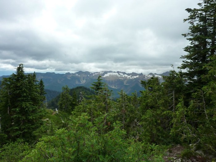
Above you are looking at a bird's eye view of the Skagit River I-5 Bridge soon after it opened for traffic in the mid 1960s.

Yesterday I blogged that the Federal Highway Administration National Bridge Inventory Database is erroneous regarding the date that the I-5 Skagit River Bridge was built, with that database saying the year was 1955, a year before the construction of the Interstate Freeway System was authorized by the Federal Aid Highway Act of 1956.

Construction of Interstate 5 in Washington did not begin until the early 1960s.

Yesterday someone named Anonymous made a post comment regarding the erroneous date...

Anonymous has left a new comment on your post "The Collapsed I-5 Skagit River Bridge Was Built in the 1960s not 1955":

The huge flood of 1955 occurred on November 4th, absent a freeway bridge. Maybe it was constructed in December of 1955? Odd time of year to build a bridge, however the Skagit Herald is rarely wrong, nor is our nation's databases.

My nephews, Jason and Joey, have been seeking proof regarding as to when the Skagit River I-5 Bridge was actually built, ever since it collapsed into the river and news reports began erroneously reporting the bridge was born in 1955, a year after Jason and Joey's dad was born.

This morning, at 5am, Jason made his way to the south end of the collapsed bridge, determined to get a photo of the plaque attached to the bridge which lists its date of birth. Jason made it past the blocking barriers, but was thwarted by a pair of Washington State Patrolmen who would allow Jason to go no further.

Jason has enlisted the help of a law enforcement friend of his to try and get a picture.

This morning Jason told me that he has learned that it was the Highway 99 Skagit River Bridge which was built in 1955. You can see the Highway 99 Bridge in the photo above, in the background behind the I-5 Bridge. The Highway 99 Bridge, apparently built in 1955, was replaced in 2004.

Somehow, perhaps when transcribing print data to digital form, the date of the building of the Skagit River I-5 Bridge was entered as 1955.

Would not one think that this is fairly easy to verify as erroneous? As in Interstate 5 was not under construction in 1955, so how could an Interstate Bridge across the Skagit River be built in 1955?


This morning Jason emailed me the two photos you see above. In the first photo you can clearly see that the two bridges are in an area of farmland, for the most part. Does it really make any sense to anyone that the I-5 Bridge sat constructed in 1955, a Bridge to Nowhere, waiting a decade for a road to connect to it?

It is interesting to look at these photos and ponder the huge changes that came to the Skagit Valley after the arrival of Interstate 5.

In the second photo we are in Mount Vernon looking north. The College Way exchange is in the foreground. The now collapsed I-5 Skagit River Bridge is near the top of the picture.

I believe the above photos were likely taken in the mid 1960s. If you were to look at the same view as these photos today, in 2013, you would see a lot of buildings and a lot of asphalt.

On the left (west) side of the freeway in Mount Vernon you'd see a Walmart Supercenter along with a lot of other stores and restaurants. After I-5 opened,  by the 1970s, on the right (east) side of I-5, in Mount Vernon, you would find a mall on both sides of College Way, replacing what had been tulip and strawberry fields.

The Mount Vernon malls have been long gone, torn down and replaced by more stores, including what at one point in time was the biggest Safeway in the world. or west of the Mississippi or something.

The Burlington side of the river saw the most drastic changes after I-5 came to town.

In 2013, in the view in the second photo of the Burlington side of the Skagit River, you would see the Cascade Mall, a complex of auto dealers called I-5 Auto World, a Costco, a big outlet center, a Fred Meyer, Target (is K-Mart still open in Burlington?), Haggen, many of the usual chain restaurants and fast food joints and a Krispy Kreme, though the donut maker may be gone.

I think I heard Krispy Kreme did not go over well in the valley.

Jason told me this morning that a lot of the Skagit Valley locals he has asked about it are as perplexed as he regarding the erroneous birth date of the Skagit River I-5 Bridge in the National Bridge Inventory Database.

I suspect this error will be corrected. Someday. Maybe.

Saturday, May 25, 2013

The Collapsed I-5 Skagit River Bridge Was Built in the 1960s not 1955

Friday morning, about 5 minutes after I learned of the collapse of the I-5 Bridge over the Skagit River in my old hometown zone of Mount Vernon and Burlington, I have been perplexed  by an erroneous bit of information that seems to be being universally accepted, that being that this bridge was built in 1955.

I have seen this error in the Skagit Valley Herald, KOMO News online, the Seattle P-I, MSNBC, CNN, FOX News (which one expects to be wrong) and virtually everywhere I've read anything about the bridge collapse.

Including Wikipedia. Within the last 24 hours Wikipedia has updated their Interstate 5 in Washington article with the bride collapse info.

Plus, Wikipedia has added an I-5 Skagit River Bridge Collapse article, which, as you can see via the screen cap on the left, also says the bridge opened in 1955.

My nephew Jason has contacted the Skagit Valley Herald pointing out that 1955 is not the correct date. Part of a reply that Jason received this morning from the Skagit Valley Herald...

The Federal Highway Administration and the National Bridge Inventory Database show the bridge having been built in 1955. I suppose that doesn’t mean it started being used then, and I’m told it was not part of the Interstate yet at that point; that part came later as the rest of I-5 was constructed.

President Dwight D. Eisenhower championed America building an Interstate System. The construction of the Interstate Freeway System was authorized by the Federal Aid Highway Act of 1956.

1956.

So, are we to believe that for some unfathomable reason a bridge to nowhere was built across the Skagit River in 1955, in anticipation of a new federal program being passed a year later, then awaiting the arrival of the Interstate Highway about a decade later?

I remember the I-5 Skagit River Bridge getting built. I was not old enough to remember anything getting built in 1955.

I remember the Ship Canal I-5 Bridge being built in Seattle, seeing the construction from the Aurora Bridge. This was a year or two after the 1962 Seattle World's Fair. And before the Interstate started being constructed in the Skagit Valley.

This repeating misinformation that the Skagit River I-5 Bridge was built in 1955 is as absurdly obviously wrong as if the Space Needle somehow came crashing down, with news articles saying it was built in 1951, when it was actually built in the early 60s, completed by the opening of the World's Fair.

I've talked to many people who remember this bridge getting built, and that construction taking place in the 1960s, not the 1950s, let alone a year before the federal act that brought about the Interstate System was passed into law.

Sunday, April 21, 2013

Concrete Washington's War of the Worlds

This morning I was reading Wikipedia's The War of the World's article about Orson Welle's Mercury Theater October 30, 1938 (Halloween) production of H.G. Well's War of the Worlds.

Orson Welle's radio version of The War of the Worlds is infamous due to the fact that it caused listeners across America, to panic, who thought they were listening to real time news about a Martian invasion.

The following blurb, in the article's section titled "Public Reaction" surprised me, due to the reference to a town in the Skagit Valley named Concrete. Growing up in the Skagit Valley I do not remember ever hearing of this interesting tidbit of Concrete history...

In Concrete, Washington, phone lines and electricity went out due to a short-circuit at the Superior Portland Cement Company's substation. Residents were unable to call neighbors, family or friends to calm their fears. Reporters who heard of the coincidental blackout sent the story over the news-wire, and soon Concrete was known worldwide.

The Wikipedia Concrete, Washington article has way more detail about the War of the World's incident.....

Orson Welles' War of the Worlds Radio Broadcast

On October 30, 1938, Seattle's CBS affiliate radio stations KIRO and KVI broadcast Orson Welles' now famous War of the Worlds radio drama. While this broadcast was heard around the country, some of the most terrified listeners were in Concrete.

At the point of the drama where the Martian invaders were invading towns and the countryside with flashes of light and poison gases, a power failure suddenly plunged almost the entire town of 1,000 into darkness. Some listeners fainted while others grabbed their families to head up into the mountains. Other more enterprising locals headed for the surrounding hills to guard their moonshine stills. One man was said to have jumped up out of his chair and, in bare feet, run the two miles (3 km) from his home to the center of town. Some of the men grabbed their guns, and one businessman – a devout Catholic – got his wife into the family car, drove to the nearest service station and demanded gasoline. Without paying the attendant, he rushed off to Bellingham (some forty-miles away) in order to see his priest for a last-minute absolution of sins. The distraught man reportedly told the gas-station attendant that paying for the gas "[wouldn't] make any difference, everyone is going to die!".

Because the phone lines (as well the electricity) were out, the town's residents were unable to call neighbors, family, or friends to verify that their fears were legitimate. Of course, the real story was not as fantastic as the fictional radio drama – all that had occurred was that the Superior Portland cement company's electrical sub-station suffered a short-circuit with a flash of brilliant light, and all the town's lights went dark. The more conservative radio-listeners in Concrete (who had been listening to Charlie McCarthy on another station), attempted to calm neighbors, reporting that they hadn't heard a thing about any "disaster". Reporters heard soon after of the coincidental blackout of Concrete, and sent the story out over the international newswire and soon the town of Concrete was known (if only for a moment) worldwide.

So, there you have it, The War of the Worlds in Concrete, Washington.

Friday, February 8, 2013

The Fidalgo Drive-In Has The Best Hamburger In Anacortes

Last night I heard from Spencer Jack, via email, that his dad's Fidalgo Drive-In in Anacortes has been determined by the voting local population to have the BEST HAMBURGER in town.

I do not remember the last time one of my relatives made any town's BEST BURGER.

I feel like I should drop in on the Fidalgo Drive-In for lunch today and have myself a burger.

Looking at the Burger Menu I think I will opt for the Tillamook Bacon Cheddar Burger, with two all-beef patties, mayo, lettuce, tomato, pickle, melted Tillamook Cheddar Cheese and bacon.

But, I am also a great fan of Bleu Cheese, with makes the Bleu Cheese Red Onion Deluxe, with two all beef patties, blue cheese dressing, lettuce, tomato, red onion and melted blue cheese crumbles, very tempting.

In my current residential location, deep in the heart of Texas, in the Dallas/Fort Worth Metroplex, I have not found any restaurant of the Fidalgo Drive-In sort, with Pacific Northwest type seafood on the menu.

I'm thinking, in addition to having the BEST BURGER in Anacortes, I should also have something from the Seafood part of the Fidalgo Drive-In menu.

SEAFOOD BASKETS come with Steak Fries, Garlic Bread, Fresh Coleslaw and a choice of  Dungeness Crab Bisque or Clam Chowder.

I think I will try and convince Spencer Jack's dad to let me have both the Dungeness Crab Bisque and Clam Chowder, along with the Seafood Combo of Cod, Prawns, Oysters & Clam Strips. I can not remember the last time I've had Cod, Prawns, Oysters or Clam Strips.

I also don't remember the last time I had a Root Beer Float.

Or a Blackberry Milkshake.

Blackberry is my favorite milkshake flavor.

I wonder if Spencer Jack will be at the Fidalgo Drive-In today, helping make the Root Beer Floats?

I've not seen Spencer Jack since last March.

It'd be a really fine thing to have lunch today in Anacortes, with Spencer Jack and his dad at the Fidalgo Drive-In....

Friday, February 1, 2013

I Am Looking For A Lost & Found Thriftique In Tacoma


This 1st day of February of 2013 is the day Tacoma's newest store is having its Grand Opening. That being the Lost & Found Thriftique, located in Tacoma's Stadium District at 118 Tacoma Avenue North.

Open from 10 am til 6 pm.

You can call 253.590.8384 or go to Facebook for more details.

Two of my favorite Tacowomans, Connie DB, aka the Original Tacoma Lulu, and Andrea Haug are the proprietresses of this latest store to join downtown Tacoma's growing number of Vintage Thrift Flea Market type stores, which are starting to give Tacoma a bit of a reputation as a destination for this type of shopping.

I was scheduled to be in Tacoma today for the Grand Opening of Lost & Found Thriftique, but last minute complications thwarted my plans.

However, I suspect I will be making a visit, sooner, rather than later.